Objectives
• Define an end-to-end pipeline from downloading satellite imagery to updating geospatial databases with current building locations
• Deploy modern deep learning methods and post-processing steps to significantly improve upon existing baseline models
• Ensure scalability for deployment across multiple sectors and geographic regions
Description
We built our solution on the foundation of the open-source RAMP platform. Using state-of-the-art models and technologies, we were able to improve overall performance significantly (see table below).
The system’s adaptability allows fine-tuning on 55,000 image chips within a single day, enabling rapid customization for new regions, building types, or evolving urban landscapes without extensive retraining cycles.
Our post-processing pipeline conducts sophisticated operations including hole filling, small object removal, and building instance expansion when necessary. We also implemented an adaptive thresholding method that can be used to adjust model sensitivity during inference, optimizing performance for specific use cases ranging from dense urban environments to sparse rural settlements.
The complete workflow processes raw satellite imagery through automated download, AI-powered building detection, quality enhancement, and seamless integration into existing geospatial information systems.
In Haiti—where building detection is notoriously difficult due to informal construction and varied materials—our solution achieved a significant improvement over the baseline:
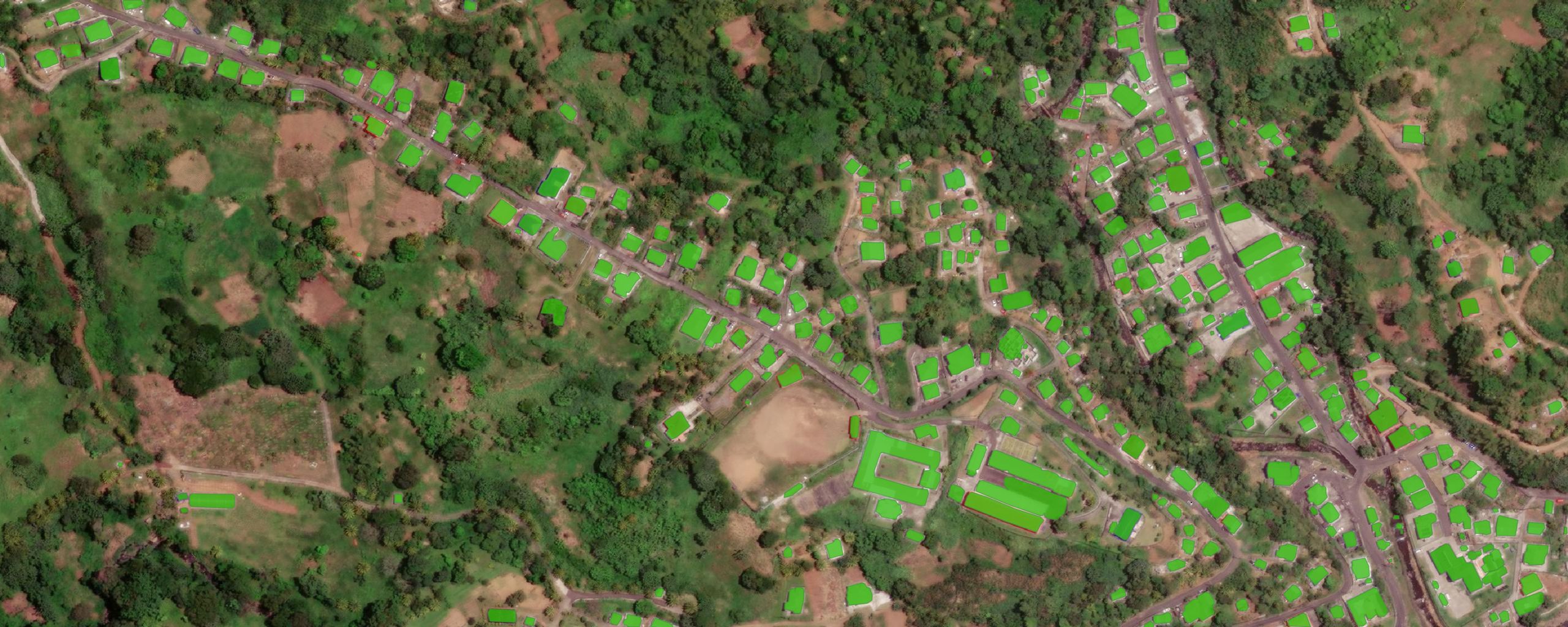
Our model predictions in green, on Mesopotamia (St. Vincent)


Geographic deployment
Assessed successfully on:
- Post-conflict areas (Afghanistan)
- Densely populated regions (Haiti)
- Complex terrain (Pakistan)
- Established urban areas (Switzerland)
Context
Planning effective interventions across sectors relies on having infrastructure datasets that are up to date. While existing geospatial databases provide settlement and population data for many countries, this data is highly volatile and oftentimes outdated by the time it is made available to planners. Thus, it is imperative to provide dataset updates on a regular basis.
One key aspect is the precise location of buildings, useful for a multitude of applications such as population estimation, urban growth monitoring, telecommunications network planning, emergency response, and risk assessment. Buildings can be extracted from high-resolution satellite imagery using deep learning models.